Last updated: Aug. 8, 2023
This post written in collaboration with Waadookawaad Amikwag
The following summarizes the causes and impacts of aquifer breaches resulting from construction of the Enbridge Line 3 tar sands pipeline. This post will be updated when new information becomes available.
Line 3 construction ended more than 19 months ago, Oct. 1, 2021. State regulators have been slow to announce all the environmental damage that occurred. They say they don’t release information until they finish their investigations.
A volunteer group called Wadookawaad Amikwag (Anishinaabemowin for “Those Who Help Beaver”) has been concerned about state agencies’ seeming lack of urgency and the lack of public information available. Volunteers are investigating on their own.
Waadookawaad Amikwag (WA) volunteers have been using drones and on-site inspections to identify potential damage, and Line 3 construction did a lot of damage. While construction did varying kinds of environmental damage, this post will focus on aquifer breaches.
Line 3’s 337-mile route went through 78 miles of wetlands. Many (if not all) wetland crossing were done in winter when the ground is frozen. Still, the groundwater only freezes down to approximately seven feet deep. Even in winter, construction workers would drive tall sheet pilings into the ground next to the planned trench to block any groundwater flow, so the area would be dry enough to work.
Line 3 also crosses lands with shallow artesian aquifers, areas where groundwater is held underground, under pressure, by an impervious confining layer such as clay. Break the clay seal with sheet piling and the water rushes to the surface.
So far, we know of four artesian aquifer breaches: Clearbrook, LaSalle Valley, the Fond du Lac Reservation, and Moose Lake. It’s not clear what caused the damage at Walker Brook. It is included here because of the extent of the damage, and to keep it the public eye.
The term “Slap-Dash Effort” is used here because calling Enbridge’s response a “repair” overstates what the company did.
The summaries below include 1) a site description, 2) the cause of the breach, 3) the amount of groundwater released, 4) Enbridge’s “Slap-Dash Effort,” and 5) Other things to know.
The term “Slap-Dash Effort” is used here because calling Enbridge’s response a “repair” overstates what the company did. Enbridge is trying to do the minimum to satisfy state regulators. These sites are not being “fixed” or returned to their natural states.
With three of the breaches – Clearbrook, LaSalle Valley, and Fond du Lac — Enbridge pumped grout (think cement) into the ground to try to plug them. Such Slap-Dash Efforts at LaSalle Valley and Fond du Lac haven’t been successful, probably doing more harm than good.
Lastly, an important qualifier. This summary includes Enbridge’s estimates on the amount of groundwater released by each breach. These underestimate the problem. These breaches occurred 12- to 39-feet underwater in wetlands. The groundwater released by the breach doesn’t necessarily all come to the surface in one spot where it can be measured. It can diffuse into the wetland before it reaches the surface, making it impossible to track.
Here’s the background.
Clearbrook Breach, Jan. 21, 2021
Site: The Clearbrook breach occurred in Clearwater County in 1855 Treaty Territory. It’s near the Clearbrook Terminal, Enbridge’s crude oil storage tank farm. The breach also is a half mile from a rare “calcareous fen.”
Cause: Enbridge said it would dig an eight-foot-deep trench, the DNR wrote in its Sept. 16, 2021 administrative penalty order. Instead, workers dug an eighteen-foot-deep trench – and installed sheet pilings 28-feet deep, breaching the artesian aquifer’s confining layer, which was approximately 18-feet deep.
Groundwater release: 72.8 million gallons, according to Enbridge’s estimates.
Slap-Dash Effort: Enbridge injected 547,692 gallons of grout underground to plug the breach, according to Enbridge’s Feb. 15, 2022 Corrective Action Implementation Report. (That’s enough grout to build a wall two-feet thick, 20-feet tall, and more than a third of a mile long.)
Other things to know:
The public is in the dark about why this happened: It is unclear why Enbridge deviated so far from its construction plan, or if the DNR has pressed the company for answers. The public deserves to know.
Enbridge was responsible to report the breech to the DNR immediately. It withheld the information for 140 days. Even then, DNR staff only learned about the breach indirectly, according to the Sept. 16, 2021 DNR Restoration and Replacement Order.
Enbridge’s Slap-Dash Efforts were slow: It would take Enbridge one year from the date of the breach to finish work trying to plug the breach — almost four months after it finished Line 3/93 construction. At last report, the breach was releasing small amounts of groundwater.
Criminal charges were inadequate: Minnesota Attorney General Keith Ellison filed one misdemeanor charge against Enbridge for appropriating waters without a permit. Enbridge admitted its role in the breach, the Attorney General’s Office said. Enbridge also admitted to delaying notification to the DNR. Enbridge paid a $1,000 fine, and entered into a diversion program. If Enbridge remained law-abiding for a year, the state would dismiss the charges. “Unless and until the Legislature changes the law, a misdemeanor is the only charge against Enbridge the State can support,” Ellison said in a statement.
Potential damage to rare fens: The breach’s “uncontrolled flow has reduced groundwater resources supplying the fens,” the DNR wrote. Fens are very susceptible to disturbance. The loss of groundwater from the breach could allow invasive plants to out compete and crowd out rare species. A DNR pamphlet on calcareous fens calls them “Amazing, Rare, Irreplaceable.” The DNR required Enbridge to pay the state $250,000 for ongoing monitoring, to put $2,750,000 in escrow if needed for restoration work, and to submit a Calcarious Fen Management Plan.
LaSalle Valley Breach, Aug. 2, 2021
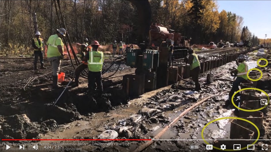
Image: Waadookawadd Amikwag video screen grab.
Site: LaSalle Creek is in the Mississippi Headwaters complex just a few miles from Itasca State Park. It’s a small trout stream which meanders through a forested valley in the 1855 Treaty Territory.
Cause: From the beginning, the DNR knew the LaSalle Valley crossing would be problematic and require additional information, according to the DNR permit. The DNR consulted with Enbridge and proposed moving Line 3’s LaSalle Creek crossing to a straighter section of the creek. In an April, 2020 meeting with Enbridge, the DNR said it needed more information about “potential artesian conditions and water management in the area.” Enbridge did additional studies. The DNR’s point person on Line 3 permits would later say that Enbridge had reported its planned trench depth to the department, but not the planned sheet piling depth. Line 3 workers drove sheet pilings 28-30 feet deep along the LaSalle Creek hillside where the artesian aquifer’s confining layer was only 12 to 18 feet. It ruptured the aquifer’s cap. The DNR’s point person on Line 3 permits said the breach resulted from “miscommunication.” Given the lengthy conversations about the LaSalle crossing, and Enbridge’s s deep pockets and skilled professionals, miscommunication on something this significant seems highly unlikely.
Groundwater released: 9.8 million gallons of groundwater, according to Enbridge.
Slap-Dash Effort: Workers inserted about 135, 23-foot long steel pipes throughout this valley and injected over 51,000 gallons of grout. In this delicate system of wetlands, it created a permanent, underground, reinforced concrete wall, over 20-feet high in places, and 2.5 football fields in length.
Other things to know:
The breach might not be fixed yet: An Aug. 4, 2022 Star Tribune article cited Enbridge saying the LaSalle breach was grouted and fixed as of November 2021. An Oct. 17, 2022 DNR and MPCA media release announcing enforcement actions against Enbridge noted that the LaSalle breach still was releasing 20 gallons of groundwater per minute. (That’s 1,800 gallons/day or 657,000 gallons/year, and again, a likely underestimate.)
Educational video available online: Waadookawaad Amikwag released an eight-minute video titled: “How Enbridge Breached the LaSalle Aquifer.”
Fond du Lac Breach, Sept. 10, 2021
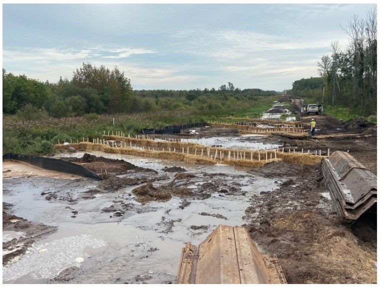
Image: Enbridge report to the DNR
Site: The breach occurred in St. Louis County, south of US Highway 2 and east of Minnesota Highway 73 in 1854 Treaty Territory. It was approximately 400 feet west of the Fond du Lac Band’s Reservation. This stretch of Line 3’s route crosses a swamp-shrub carr wetland, which St. Louis County describes as occurring in “organic soils (peat/muck) as well as on the mineral soils of a floodplain. These wetlands are waterlogged much of the growing season and often covered with as much as six inches of water.”
Cause: In late January, 2021 workers drove sheet pilings 27 feet into the ground. The aquifer’s confining layer was approximately 30 to 39 feet deep. The groundwater release didn’t start until Sept. 10, 2021, when crews used vibration hammers to loosen and remove the sheet pilings. Artesian aquifer’s confining layers are often something relatively strong, such as clay. This location had a particularly weak confining layer, made of “native silts and fine sands,” according to Enbridge. The company hypothesizes that the vibrating hammers used to remove sheet pilings “liquefied” the silt-and-sand aquifer cap below the pilings, leading to the breach.
Groundwater released: 263 million gallons, according to Enbridge.
Slap-Dash Effort: Enbridge pumped 150,000 gallons of grout underground.
Walker Brook, Aug. 17, 2021

Site: Walker Brook is near Bagley in Clearwater County, and is in 1855 Treaty Territory. The valley is full of complicated layers of glacial sediments and interconnected wetland systems.
Cause: The pipeline ran straight down a fairly steep hill in an area with a high water table. It appears that the water in hillside began flowing downhill along the path of least resistance – the buried pipeline and the trench. It created erosion next to the pipeline, raising concerns about its stability.
Groundwater released: Unknown.
Slap-Dash Effort: Enbridge made two to three efforts to address the breach. In the most recent effort, workers stripped the top two-and-a-half feet of topsoil along one hillside, in an area 20-feet wide and 280-feet long. They replaced it with a foot of sand, a foot of gravel, and a half foot of topsoil. The goal was to move drainage away from the pipeline. The sand and gravel are a sterile environment. Enbridge has completely changed this once pristine forested peat land.

it with sand, gravel, and a little topsoil.
Other things to know:
Video available: Waadookawaad Amikwag released this 5-minute video discussing Walker Brook’s construction damage.
Missing information: State agencies have not reported on this location to the public, explained the type of hydrologic damage that occurred, or their analysis of its cause.
Moose Lake breach, date unknown
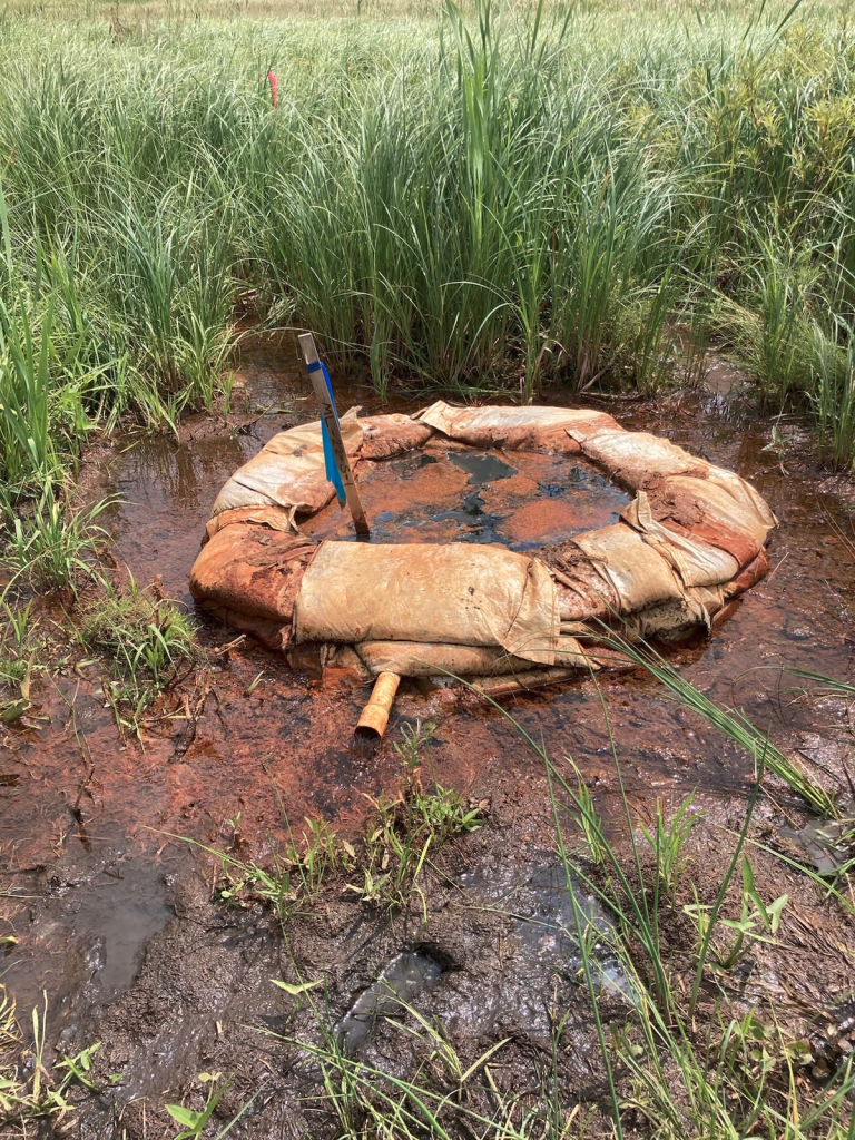
Photo: Waadookawaad Amikwag, July, 2023.
Site: Construction occurred in a peat land area south of Moose Lake, a wild rice lake in Aitkin County in 1855 Treaty Territory. Peat lands are composed entirely of organic matter and saturated with water
Cause: Workers laid the pipeline during the winter when the ground was frozen. Even then, workers used sheet pilings “due to the unstable nature of the floating mat peat in this area,” Enbridge wrote in an Oct. 3 memo to the DNR and the MPCA. The artesian aquifer confining layer here is 16- to 20-feet deep. Workers drove sheet pilings 28 feet deep and punctured it, according to an April 21 memo from Enbridge to the DNR and the MPCA.
Groundwater released: Currently no estimates.
Slap-Dash Effort: Nothing yet.

shared on twitter and facebook, thanks bud
LikeLiked by 1 person
GREAT SUMMARY, SCOTT! This will be a place to send people to get up to date on the concerns that remain here along the Enbridge corridor. Miigwech!
LikeLiked by 1 person
[…] For a summary of the aquifer breaches, their causes, and damages, click here. […]
LikeLike